For more than 200 years, the standard map of the world has been based on a 1569 chart of the globe pioneered by Flemish geographer Gerardus Mercator (1512–1594).
But in spite of its historic popularity, the Mercator Projection the has long been recognised as problematic. The main issue is that, for navigational reasons, it artificially enlarges the regions nearest to the poles, making Africa – which straddles the equator – appear roughly the same size as Greenland, despite being about 14 times larger.
On 4 September 2026, the UN passed a motion tabled by representatives from Togo and backed by a number of African nations, to endorse and adopt a new world map. The map in question is the Equal Earth Projection, developed in 2018 by prominent cartographers Bojan Šavrič, Tom Patterson and Bernhard Jenny.
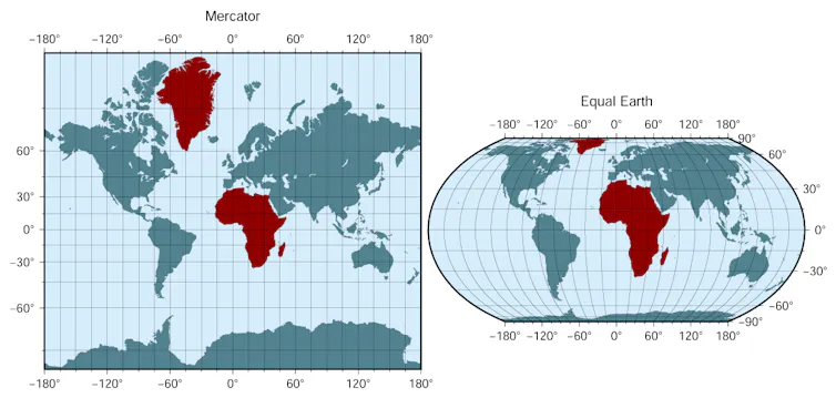
It will, in theory, replace the Mercator Projection, which the Togo campaigners say risks insinuating that Africa and its peoples are politically and culturally peripheral. The Equal Earth Projection corrects this distortion by accurately depicting the relative areas of the continents.
This critique of Mercator is timely and important, and it also taps into a long history of disputes about how the continents should appear on the map.
Their sizes, and the politics of their representation, were already major points of contention for the ancient geographers of Greece and Rome, including Herodotus, Strabo and Pliny (the Elder), and each approached the depiction of the planet from a different perspective.
1. Herodotus on the symmetrical Earth
One of the earliest recorded attempts to correct the map comes from the fourth book of Herodotus’ Histories (5th century BCE). In it, the Greek geographer and historian mocks the work of earlier cartographers and accuses them of making their maps artificially symmetrical:
I laugh when I see that, though many before this have drawn maps of the Earth, yet no one has set the matter forth in an intelligent way; seeing that they draw Ocean flowing round the Earth, which is circular exactly as if drawn with compasses, and they make Asia equal in size to Europe.
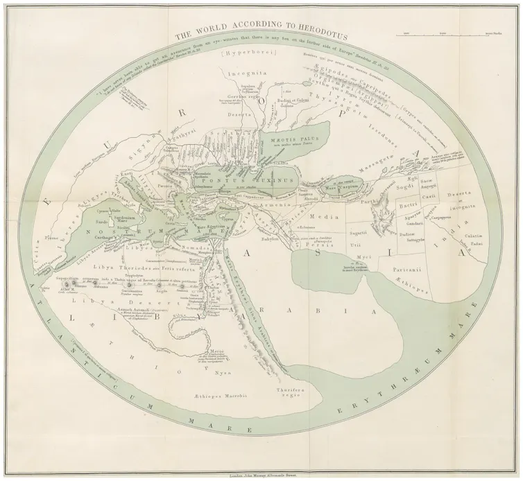
Herodotus replaces this world picture with a strikingly different vision of the Earth in which Europe dwarfs both Asia and Libya (the name he uses to refer to Africa):
I wonder then at those who have parted off and divided the world into Libya, Asia and Europe, since the difference between these is not small; for in length Europe extends along by both, while in breadth it is clear to me that it is beyond comparison larger.
2. Strabo on scale and power
Herodotus gives no overall measurements of Libya (Africa). He describes it as very broad, connected to Asia, and smaller than Europe. The Greek geographer Strabo, writing under Roman rule (1st century BC), offers a different assessment. In the 17th book of his Geography, he challenges the conventional threefold continental division on the grounds that Libya falls far short of a third of the inhabited world and may in fact be smaller than Europe:
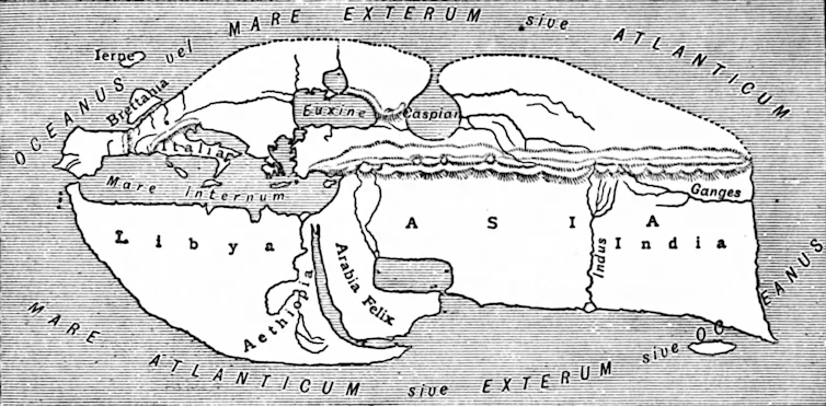
Now the writers who have divided the inhabited world according to continents have divided it unequally, for the threefold division indicates a division into three equal parts; but Libya lacks so much of being a third part of the inhabited world that even if it were combined with Europe, it would seem not to be equal to Asia. Perhaps it is even smaller than Europe; and in power it is much inferior.
The vision of the Earth supplied by Strabo is a striking departure from Herodotus, with Asia occupying more of the inhabited world than Europe and Libya combined. But most consequential is his claim about what such differences in size represent.
By connecting the small scale of Libya to its allegedly inferior power and drawing attention to its deserts and scattered settlements, he invites his readers to imagine that the size and character of a territory determine its political power.
3. Pliny on geography and empire
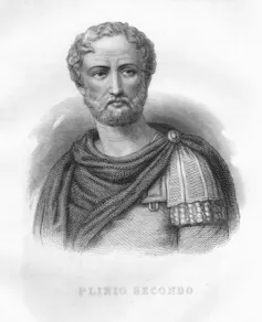
The connection between size and power is made even more explicit by the Roman naturalist Pliny the Elder in his Natural History (1st century BC). He offers a vision of the world reminiscent of Herodotus in which Europe is by far the largest of the continents:
To begin then with Europe, nurse of the race that has conquered all the nations, and by far the loveliest portion of the Earth, which most authorities, not without reason, have reckoned to be not a third part but a half of the world, dividing the whole circle into two portions by a line drawn from the river Don to the Straits of Gibraltar.
Later, he gives a more detailed account of these divisions, based on some confusing measurements drawn from several, sometimes conflicting, sources:
It is consequently clear that Europe is a little less than one and a half times the size of Asia, and two and one sixth times the width of Africa. Combining all these figures together, it will be clearly manifest that Europe is a little more than 1/3 + 1/8, Asia ¼ + 1/14, and Africa 1/5 + 1/60, of the whole Earth.
Pliny effectively inverts the point made by Strabo about the relationship between the small size of Libya and its lacklustre profile on the world stage and applies it to Europe. He situates his claim about the size of Europe right next to his celebration of it as the homeland of the Romans, who have become conquerors of the entire world. The juxtaposition suggests that the masters of the Earth fittingly occupy its greatest and most beautiful portion.
These episodes show us that, long before the debate over Mercator, the representation of the sizes of the continents was already entangled with questions about power and prestige.
The campaign for the Equal Earth Projection, and the proper recognition of the scale of Africa, proceeds from this same, ancient assumption: that the way a continent appears on the map can shape perceptions of its place in the world.
This article features references to books that have been included for editorial reasons, and may contain links to bookshop.org; if you click on one of the links and go on to buy something, The Conversation UK may earn a commission.