On 26 August, an avalanche and massive flood swept through Nepal’s Rasuwa district. Thousands of lives were lost, homes were destroyed, roads and energy infrastructure were washed away, and trade and tourism were disrupted.
Disaster early-warning systems can succeed — but collective action is needed
This catastrophe should not be treated as just another disaster. It is the latest — and worst — in a series of exceptionally massive deluges of rock, ice and debris from mountains. The unprecedented scale of the damage shows that current approaches of assessing and managing these risks have failed. Moreover, with global warming accelerating, further disasters of this magnitude are expected.
How scientists analyse and officials manage environmental risks in mountainous regions must urgently be restructured. Here we outline how such hazards are changing and propose how researchers can assess coupled, cascading risks to protect communities and save lives.
Successive extreme disasters
The Rasuwa disaster is not a freak event. Over the past few years, the world has seen several similar massive rock and ice collapses with ensuing floods (see ‘Cascading risks’).
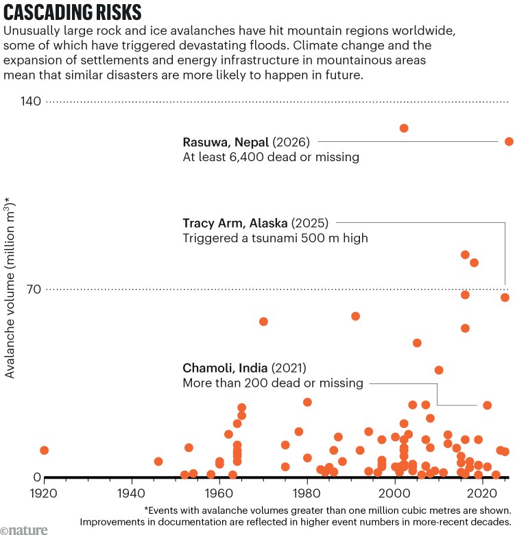
In February 2021 in India, an avalanche from Ronti peak led to a huge flood in the Chamoli district of Uttarakhand. The flow of water and debris devastated the Ronti Gad valley, killing more than 200 people and destroying hydropower structures1.
Just a few months later, in June 2021 in Nepal, a small glacial lake burst its banks, sending flood waters surging into the Melamchi River. This triggered a cascade of hazards that washed away more than 50 million cubic metres of sediment and altered river-bed levels by roughly 20 metres in some places2. Around 600 people were displaced and at least 20 died. The region’s freshly established drinking-water infrastructure was severely damaged and vast areas of agricultural land were lost.
Losing your way of life to climate change matters — and we need a way to measure it
Similarly, in October 2023 in Sikkim, India, a massive slide of glacial sediment into South Lhonak glacier lake initiated another outburst and flood. The waters swept an incredible 270 million m3 of sediment down the Teesta River. More than 100 people died, around 26,000 buildings were damaged and hydropower structures were destroyed. The impacts, including infrastructure damage, affected Bangladesh, too3.
Furthermore, in May 2025, the village of Blatten in the Swiss Alps was buried under an avalanche that released nearly 10 million m3 of rock and ice after a glacier collapsed. The glacier was weakened by a series of rock slides that deposited material onto it4. The village was destroyed and there was one fatality, but the other residents were evacuated before it was inundated.
And, in Alaska, less than three months later, an extraordinary landslide (roughly 64 million m3) crashed onto South Sawyer Glacier and into Tracy Arm Fjord5, generating a tsunami with heights of close to 500 m. Fortunately, this happened a few hours before cruise ships would have been travelling through the fjord, avoiding what might have been a maritime disaster.
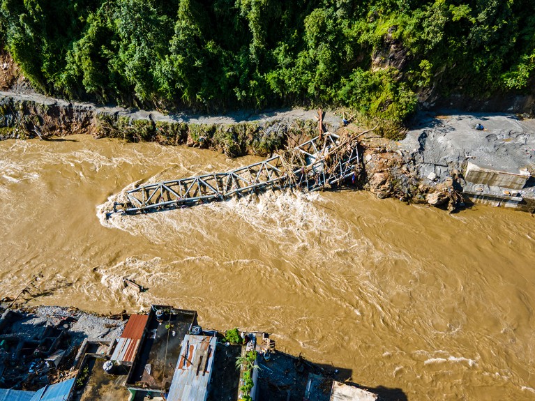
The Rasuwa disaster exceeds these events. On the northern slopes of Langtang Lirung mountain, a failure in the bedrock caused a massive rock avalanche that took the overlying glacier with it. The resulting avalanche (around 125 million m3 of rock and ice) is one of the largest on record worldwide.
As the ice, debris and water rushed down the Lhende Khola, Bhotekoshi and Trishuli river valleys, the ice melted and extra sediment and water were incorporated into the flow. Damage extended over 100 kilometres from the source. More than 1,400 people have died, more than 5,000 are missing and tens of thousands have been displaced. Settlements, roads and bridges were washed away and around 10% of Nepal’s hydropower production was knocked out. Reconstruction costs have been put at around US$5 billion.
And on 11 October, the Himalaya region of central Nepal was hit by floods in the upper Budhi Gandaki river valley that were triggered by another large rock and ice avalanche from a steep mountain slope. The avalanche was around half the size of the August collapse. The floods damaged settlements, roads, bridges and hydropower structures.
Growing hazards and exposure
These events resulted from a combination of interacting and cascading processes: collapses of steep rock or glacier slopes, failures of banks of sediment, outburst floods from lakes and further entrainment of water, debris and sediment by the flood as it raced downstream.
The scientific community knows this and has repeatedly signalled the need for an improved understanding of these cascading hazards and for them to be incorporated into risk analyses6,7. But, so far, little has changed in how such hazards and risks are considered in practice.
The likelihood of one-off events is typically gauged on the basis of the historical record. But events at the scale that we are now seeing are rare or missing from those archives. That makes it hard to predict how frequently massive avalanche-triggered floods might occur in future — the number seen over the past few years is too small to determine long-term trends. But one thing is certain: the world is warming, meaning further rock-slope failures and glacier collapses are likely to occur in coming decades. What has happened historically will not be a good model for what is to come.
Expanding development in mountainous areas is also increasing the exposure of people, settlements and infrastructure to hazards. For example, hydropower development in the Trishuli basin in Rasuwa has expanded since 2010, as has development along the road to the Rasuwagadhi–Kerung border between China and Nepal.
Re-evaluate risk analysis
Scientists and decision makers must rethink how they analyse hazards and risks in mountainous regions. Rather than a single method, we propose a complementary set of approaches that can be combined as needed depending on the context.
First, define the purpose and scope of the assessment. For instance, a risk analysis can inform land-use planning, guide funding allocations, identify protection gaps, calculate potential economic losses or establish priorities for risk management at scales ranging from a single hydropower plant to large populated areas. Together, governments and local communities need to decide what level of risk they are willing to tolerate and consider how to protect the most-vulnerable groups and infrastructure.
Second, we suggest applying a combination of several risk-evaluation methodologies. Each approach covers a specific risk aspect and is complemented by the others. Disasters such as the one in Rasuwa underline the importance of using several tools to capture the multifaceted impacts comprehensively.
Probabilistic risk analysis can be used to compute the distribution of asset losses for events of various sizes and frequencies8. For example, for a hydropower plant, such an analysis might provide a statistical representation of the extent of damage in relation to different event probabilities.
AI to the rescue: how to enhance disaster early warnings with tech tools
However, performing a probabilistic analysis is challenging when assessing future events that have few or no precedents. In such cases, we suggest that analysts consider using models of credible, physically plausible scenarios. These can be built from likelihoods and judgements based on existing knowledge9 and by extending the analysis to a wide range of possible events.
For this, the geological record can sometimes provide clues. For example, in Rasuwa, large boulders lying well beyond the current river bed are testimonies of similar floods some 5,000 years ago10. A plausibility analysis would then check whether such an event is plausible under current or near-future conditions.
Storyline approaches that consider a range of far-reaching possibilities in both qualitative and quantitative ways should be applied to explore cascading effects beyond current populations and structures11. For instance, the Rasuwa disaster destroyed important trade and transport routes between Nepal and China with consequences for Nepal’s economy. The destruction of hydropower sites also affects neighbouring countries that depend on energy imports, including Bangladesh.
Risk-network analysis can be used to address gaps in risk assessments, such as the lack of inclusion of the consequences for disadvantaged populations. Such methods evaluate, for example, connections between flooded houses and their inhabitants, lost local businesses and livelihoods, and disruptions to social networks and education and health-care services.
Enjoying our latest content?
Log in or create an account to continue
- Access the most recent journalism from Nature's award-winning team
- Explore the latest features & opinion covering groundbreaking research